17 November 2022
It has never been easier to develop compact, sophisticated radars with low size, weight, power and cost
There is an increasing interest in applying radar technology in various new use cases, applicable to both commercial and military applications. A common denominator in these new applications is the need for high performance, low cost, compact footprint and the need to be able to operate in various modes, depending on the situation. Given the complexity of combining leading performance of the hardware with advanced signal processing, there is also a growing need to reduce cost, risk and time to market for these sophisticated radar systems.
Sivers Semiconductors has worked closely with aiRadar to provide the necessary silicon components and antenna hardware to enable a radar concept characterized by multi-mode and multi-mission capabilities together with software-defined radar functionality suitable for advanced driver assisted systems, small unmanned aerial vehicles (UAVs) as well as sensors to identify natural disasters.
The new series of radar products from aiRadar is now available and will facilitate radar research and development from early proof of concept through requirement definition and validation to system design, validation and deployment.
Different sensor technologies are suitable for different missions
Radar and LiDAR technology are like siblings in the sensor space. Both send out a wireless signal and detect what is reflected by the illuminated object. The difference between these technologies is primarily the wavelength of the transmitted signal, which has an impact on how well it travels through non ideal conditions like fog, rain and snow. LiDAR is not a preferred solution in rough outdoor conditions with likely occurrence of rain, fog and/or snow, under those conditions a high performing radar is more suitable. However, since the LiDAR can give extremely good performance under ideal conditions, it is likely we will see the two technologies complement each other in many applications.
In this insight article, we will focus on the radar perspective and discuss the requirements and possible solutions for some interesting and relevant applications, which also can act as appetizers and inspiration for other use cases.
Syntethic aperture radar systems are typically deployed on larger drones or aircrafts, and it has been demonstrated by researchers on small drones (<50 kg). But space varying errors due to aerodynamic turbulence and flight path position as well as altitude errors degrades the resolution and are an obstacle to wider deployments on small UAVs.


Synthetic Aperture Radar (SAR)
A Synthetic Aperture Radar is an imaging radar mounted on a moving platform. Similar to a conventional radar, electromagnetic waves are sequentially transmitted, and the backscattered echoes are collected by the radar antenna. In the case of SAR the consecutive time of transmission/reception translates into different positions due to the platform movement. An appropriate coherent combination of the received signals allows the construction of a virtual aperture that is much longer than the physical antenna length. This basic attribute of SAR is the origin of its name “synthetic aperture,” giving it the property of being an imaging radar.
Interferometry SAR (InSAR)
is a powerful and well-established remote sensing technique that enables the highly accurate measurement of important geophysical parameters such as surface topography, ground deformation and subsidence as well as glacier movements. The key idea of SAR interferometry is to compare for a given scene the phase of two or more complex radar images that have been acquired from slightly different positions or at different times. Since the phase of each SAR image pixel contains range information that is accurate to a small fraction of the radar wavelength, it is possible to detect and measure tiny path length differences with centimetric or even millimetric accuracy. This outstanding accuracy is independent of the distance between the sensor and the scene which makes SAR interferometry highly relevant for both air- and spaceborne remote sensing.
Situation for various use cases
Autonomous driving
Advanced driver assistance systems require excellent moving target identification processing to separate stationary infrastructure, such as building and traffic signs, from moving objects like cars, trucks, cyclists and pedestrians. The 57-71 GHz band provide good conditions for both sensitivity and resolution of moving objects. But most radars currently deployed in automotive applications have a very coarse resolution and typically these radars can detect an object like a motorcycle, a person or a truck, but the object is represented by little more than a “blob”.

To recognize the object correctly, the task of recognition is largely offloaded to an artificial intelligence (AI) or machine learning (ML) algorithm within the system. From system perspective, this increases the amount of signal processing needed with all of its consequences (e.g. energy consumption, system complexity etc.) It also means that advances in artificial intelligence hardware and software algorithms are tasked with providing that one crucial step to a fully autonomous and safe vehicle.
There may be several reasons for this allocation of functionality, but it is likely the requirement definition and validation, followed by the design and manufacture of advanced, modern radar systems using advanced electronically scanned phased arrays (AESA) is difficult. This difficulty translates into various risks in terms of technical performance, schedule and cost. But the availability of low cost and low risk type of systems may enable changes to this allocation and, perhaps, advances in autonomy levels.
When you dig deeper into the product assurance of such complex and advanced AESA radars, you realize this is not trivial. What can be seen as simple requirements can have a direct and severe impact on resolution and accuracy of the system. The consequence is that the quality of the image or the accuracy of the location or the speed of the object degrades. This lack of resolution and image quality will have a negative impact on the AI/ML interpretation of the scene.
Commercial security
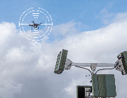
A growing number of radar applications have emerged recently, where current radar platforms perform poorly or are simply not suitable. Examples of these applications are ground deployed (and human portable) real aperture radars for detecting and monitoring small drones, which pose security threats as well as small UAV-deployed high resolution image radars, using synthetic aperture and/or real aperture radars.
Flooding disasters and other natural disasters are getting more and more frequent as the climate changes more to the extreme. Early warnings if riverbanks or slopes are about to subside is critical in our effort to save lives and suffering among the population. In this specific use case an interferometric synthetic aperture radar can provide high-resolution scenes superimposed on digital surface models. This can be captured in real time as riverbanks or slopes subside. This can also be combined with the identification of objects of interest with overlay of moving target indication attached to these objects.
Military applications
The ongoing military conflict in Ukraine highlights the use of military radar applications. Hostile drones are extremely dangerous in the way they are locating enemy forces, providing intel on those forces, directing artillery fire with devastating accuracy and how they assess damages after attacks. In this context, countermeasures to these hostile drones is an obvious need, but while open literature shows many small UAV detection systems, there is little proof of them being successfully deployed in this conflict.
Synthethic aperture radars (SAR) offers extremely high resolution, but require motion, while real aperture radars (RAR) provide excellent image quality from a stationary position. A small UAV deployed small aperture radar with 3-dimensional interferometric SAR generating digital surface models might be the preferred solution for both pre- and post-operation with high resolution threat and damage assessment. At the same time, a small UAV deployed real aperture radar with an electronically scanned phased array radar may be better suited for real-time target spotting.
One solution – multiple use cases
It is a challenge to realize a software defined radar as an economic and affordable solution based on a single hardware platform with common interfaces and small footprint supporting multiple applications, multiple modes, and multiple missions.
aiRadar started their work to address this several years ago and one of their early decisions was to base their solution on a hybrid beamforming architecture with analog beamforming at the level of 16 antenna elements and digital beamforming at a higher level, reducing the number of analog to digital converters as well reducing the data rates.
At this early stage, it became obvious that Sivers Semiconductors’ capabilities within RFIC, antennas and subsystems was a great fit to the concept aiRadar was looking for. Initially it was important to be able to facilitate the granting of experimental and research licenses, which was directly supported by the available RFIC TRXBF01 from Sivers Semiconductors. The first offering from aiRadar has a centre frequency of 66 GHz within the unlicensed 57-71 GHz band. It was also important to be able to offer other frequency bands, like the 24 GHz band as an option to the generic system platform offered by aiRadar. The TRXBF02, operating on the 24.0-29.5 GHz band combined with the digital system control and the common interface to the transmit/receive modules enables very fast and easy hardware reconfiguration of the system to operate e.g. on the unlicensed 24.0-24.25 GHz band.
Based on the same system and RFIC architecture, it is also possible to reconfigure the system to support the 76-81 GHz band, which is of great interest to the automotive industry. This is a frequency band under evaluation from Sivers for future products.
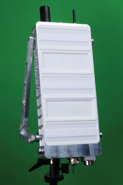
Through close cooperation between Sivers and aiRadar a custom version of an active antenna module was developed. This module enables 16 TX and 16 RX to operate over a full 14 GHz frequency band (57-71 GHz). By means of the interfaces for coherent multi-module electronically scanned antenna array, this device enables a 5 cm range resolution. The 16 channels of RX data is not only the enabler of high resolution, it also enables, efficient imaging, multi baseline moving target identification and the data for displaced phase centre antenna micro-navigation.
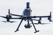
The new series of radars from aiRadar support full multi-mode and multi-mission operation. They can switch seamlessly between a sector scanner covering 90 degrees with better than 0.5 degrees angular resolution to a small UAV deployed single pass interferometric SAR with range and resolution better than 5 cm. The radars range from the smallest model with a mass of 3.8 kg, comprising three transmit and three receive 64 element arrays, to the largest model with a mass of less than 10 kg comprising app 1.00 active elements in an identical array but with 256-element arrays.
With its smaller footprint and weight combined with system features like the multi aperture SAR capability, the displaced phase center antenna micronavigation, dual GNSS (GPS) receivers, nine-axis altitude sensors and time domain loop-back projection to support full unsupervised SAR processing, the aiRadar solution is well suited also for deployment on small UAVs.
A technical deep dive of this new product line was covered in the September issue of the Microwave Journal, where Sivers and aiRadar presented an invited paper for a Cover Feature of the month. (https://www.microwavejournal.com/articles/38807-advanced-multi-mode-multi-mission-software-defined-mmwave-radar-for-low-size-weight-power-and-cost)
Proof points
In the following figures, several images are shown to reflect the performance of the aiRadar product.
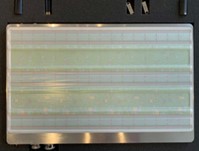
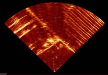
In figure 10, an image is showing two parking lots with vehicles, dumpsters and a railway switching yard. A range of 50 m is selected to demonstrate the filtering and downsampling of the 200.000 range samples at 5 cm resolution.
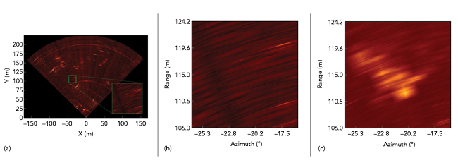
In figure 11, a stationary radar image is shown with normal processing (a), expanded view of the highlighted area (b) and highlighted with motion target indicator (MTI) processing (c). In (c) the moving targets that were invisible in (a) is now fully visible due to the MTI processing.
Conclusion
By means of the deep collaboration between aiRadar and Sivers Semiconductors, it is now possible to develop compact, low size, weight, power, and cost radar systems based on the latest technology in advanced electronically scanned phased array mmWave technology. By supporting critical features like real aperture radars, synthetic aperture radars (also supporting interferometric SAR), multi baseline interferometry, moving target identification and cognitive adaptive radars, the aiRadar system is a perfect fit to various use cases like sensors for autonomous driving, commercial security, and military applications
These new products offer a great opportunity to researchers and radar developers to validate requirements and develop sophisticated radar systems with a low-risk path to commercialization and deployment.
For more information, please contact: [email protected] | [email protected]